

 Bildrechte: NLWKN
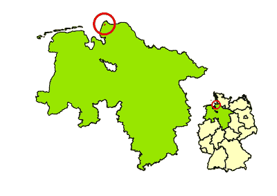
Location and Size of the Project Area
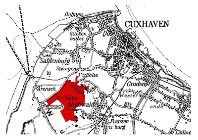
The project area is located in the Cuxhaven region between the urban districts of Altenwalde (to the east), Oxstedt (to the south), Berensch (to the west) and Holte-Spangen (to the north).
 Bildrechte: NLWKN
Overview map – Location of the project area in Germany/Lower Saxony
 Bildrechte: NLWKN
Detailed map of the project area
The project area has a size of approximately 580 hectares, of which 158 hectares are forest and 422 hectares consist of open area habitats (mainly heath and lean turf), interspersed with shrubs and small trees.
Visitors travelling in their own cars should use the parking area on the road K7 between Holte-Spangen and Berensch (approximately 1km after leaving the village of Holte-Spangen).
Click on the link below to see the parking area on a map. You can zoom in and out of the map using the red bar at the bottom:
Bildrechte: NLWKNLinks to further information about
- LIFE Nature Project
- Project Sponsors and Financing
- Project Goals
- Project Organisation
- Location and Size
- Usage History
- Geology and Soils
- Biotope and Habitat Types
- Animal and Plant Species
- Project of National Significance
- Natura 2000, Nature Reserve
- Heck Cattle and Konik Horse Grazing
- Wisent Grazing
- Small Ponds
- Development of Forests Suited to the Location
- Removal of Small Trees and Shrubs
- Information for Visitors
Artikel-Informationen
Ansprechpartner/in:
Hannah Burmester
Nds. Landesbetrieb für Wasserwirtschaft, Küsten- und Naturschutz
Betriebsstelle Lüneburg
Adolph-Kolping-Str. 6
D-21337 Lüneburg
Tel: +49 (0)4131 2209-221